3D Geotechnical Modelling for a Heavy-Haul Railway in Brazil
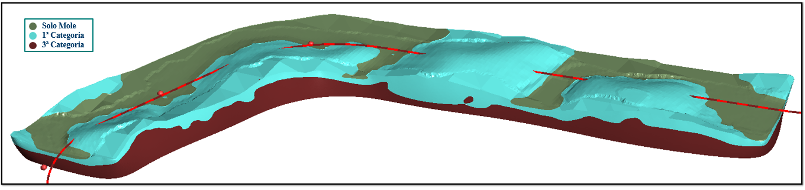
Over 900 line-km of helicopter-borne EM Geoscanning data, 983 geotechnical boreholes, and machine learning were combined to build a 3D geological-geotechnical model for the Anchieta railway corridor in Espírito Santo, Brazil. Delivered in 2023 and updated in 2025 with new strategic boreholes, the model identified soft-soil zones in locations drillers could not access, produced precise excavation-volume estimates with full uncertainty maps, and enabled optimised foundation solutions — demonstrating that geotechnical models are living deliverables that compound in value as new data are added.
Introduction
Large-scale railway projects, particularly those designed for heavy-haul freight, face fundamental geotechnical challenges: heterogeneous geology, variable bedrock depth, and localised soft-soil deposits that demand specific foundation treatment. Traditional characterisation through SPT and mixed boreholes provides discrete, point-based information that must be interpolated — a process that risks missing lateral heterogeneities and abrupt subsurface transitions, with direct consequences for earthwork cost estimates and foundation design.
This study presents the integrated application of Airborne Geoscanning across 900 line-km of flight lines in a corridor exceeding 400 m width, combined with 983 boreholes and machine learning, to construct a 3D geological-geotechnical model for the Anchieta railway in Espírito Santo, Brazil. An artificial neural network modelled the bedrock interface across 46 interpreted zones, while a Random Forest classifier produced probabilistic 3D material classifications based on granulometric and mechanical excavation categories. Nine strategic drill points were added to guide the 2025 model update, sharpening the original 2023 model ahead of executive design — a direct illustration of how iterative integration of new boreholes continuously improves prediction accuracy across the project lifecycle.
Conclusions
The comparison between the 2022 original design — based solely on 2D interpolated profiles — and the 2025 revision supported by the 3D model provided clear, quantified evidence of the gains delivered. Excavation volumes for a representative cut section more than doubled, with 2nd-category material rising from around 9,200 m³ to 82,600 m³, driven primarily by improved geological interpretation. In soft-soil areas inaccessible to drillers, the 3D model enabled geotechnical analogy across the mapped lowland context, replacing a granular column solution with complete soft-soil removal — a technically more appropriate and economically optimised outcome. The study confirms that integrating airborne geophysics with conventional investigations reduces uncertainty, improves engineering decision quality, and — crucially — that every new borehole fed back into the model makes the next prediction better.
(To be) published at the XXII Brazilian Congress of Soil Mechanics and Geotechnical Engineering (COBRAMSEG 2026), Brasília, August 2026. Authors: Kíssyla Ávils Costa and Stephane do Nascimento Santos (VALE); Craig William Christensen, Fernando Pacheco, and Priscila Rodrigues (EMerald Geomodelling). Article will be available for download after the conference.
Success Stories
Discover how our clients have leveraged our expertise to improve their projects, overcoming challenges and achieving success through innovative ground modelling solutions.


Our Solutions
We follow a structured process for geological assessments, from initial data collection to 3D modelling and interpretation, ensuring accurate analysis. Our flexible timelines and customized solutions adapt to project-specific challenges, delivering insights for infrastructure development.