Predicting Rock Quality from the Air: RQD Modelling for a Himalayan Railway Tunnel
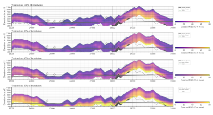
A machine learning regression workflow was applied to AEM resistivity data and 65 geotechnical boreholes along a 40 km Himalayan rail corridor in Uttarakhand, India, to predict Rock Quality Designation (RQD) continuously in 3D — with quantified uncertainty at every point. Simulation tests showed that 40–50% fewer boreholes are sufficient to recover the principal large-scale rock-quality structures, pointing to significant potential for reducing or better targeting ground investigation campaigns in future early-phase tunnel projects.
Introduction
In mountainous terrain, surface-based geotechnical investigations are slow, costly, and often physically inaccessible. For railway tunnels — where rock quality governs excavation method, support class, and construction risk — the ability to anticipate subsurface conditions ahead of drilling is of high engineering value. Airborne Geoscanning (AEM) surveys offer continuous resistivity imaging of the subsurface, but translating those resistivity models into engineering-relevant parameters has, until now, been limited to categorical outputs such as lithology or weathering class.
This paper presents the first application of a regression-based machine learning workflow to predict Rock Quality Designation (RQD) from helicopter electromagnetic data, extending the established volumetric classification framework developed by EMerald Geomodelling. The study was carried out along the Rishikesh–Karanprayag rail line in Uttarakhand, India — a new broad-gauge route crossing some of the world's most challenging terrain — using EM data acquired across a 40 km demonstration corridor and RQD logs from 65 boreholes reaching depths of up to 390 m. An ensemble of artificial neural network regressors was trained to predict mean RQD over 10 m vertical windows, with the ensemble spread used as a spatially explicit uncertainty estimate. The resulting 3D model covers the full resistivity volume, including off-alignment areas inaccessible to drillers.
Conclusions
Cross-validated against withheld borehole data, the model achieved a mean absolute error of 11.1 percentage points, recovering the principal large-scale rock-quality structures along the corridor. Predictions along the already-excavated Tunnel 1 were qualitatively consistent with as-built observations.
A borehole-subset experiment demonstrated that using only 40–50% of the available boreholes still preserves the dominant structures in the predicted RQD field — suggesting that future ground-investigation campaigns on similar corridors could be substantially reduced in volume, or more usefully redistributed to prioritise critical zones rather than uniform spacing. With 4 zones of low RQD flagged for early engineering response and a validated workflow ready to scale to the full 125 km route, the study demonstrates delivery of engineering-relevant 3D ground models under some of the world's hardest helicopter geoscanning acquisition conditions, with rigorous uncertainty quantification on every prediction.
(To be) published at the 9th International Airborne Electromagnetics Workshop, 7-11 September 2026, Favignana, Italy. Article will be available for download after the conference.
Success Stories
Discover how our clients have leveraged our expertise to improve their projects, overcoming challenges and achieving success through innovative ground modelling solutions.


Our Solutions
We follow a structured process for geological assessments, from initial data collection to 3D modelling and interpretation, ensuring accurate analysis. Our flexible timelines and customized solutions adapt to project-specific challenges, delivering insights for infrastructure development.